- RGA Day 11 - Overview
- Photos
Sunday, July 6, 2008
La Route des Grandes Alpes Day 11: Barcelonette to Saint-Bonnet-en-Champsaur
88.6 km total
Le Collet 991m
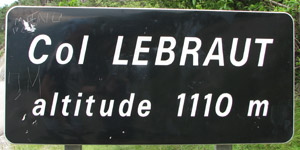
Col Lebraut 1,110m
We woke up with perfect sunshine but as soon as we left Barcelonette, the first drips started to come down.
The rain was not so bad but because the road was soaked and as we were riding down in the direction of the Lac du Serre-Ponçon, we picked up speed and were sprayed all over. Weather and road got better around Le Lauzet-Ubaye, where we started the climb along the south side of the lake. We expected that the D900b would be a nicer road than the N94, which passes north of the lake. Then we continued over the Col Lebraut on the west side of the lake.
At the start of the col lies the Serre-Ponçon dam. This dam is Europe’s largest earth dam at 123m high, 600m across and 600m thick at the base.
Top of the col meant rolling downhill again. As we arrived at Chorges, the sunny weather had swapped for big clouds. We found cover just in time. Once that passed, we had not much choice but to taste a small piece of N94. By now we knew we had been right to pass south of the lake. After a few kms we veered off onto the D14 to the right and started the climb in the direction of the Col de Manse (1,268m). As our road passed just right of this pass, even though we made it to the same altitude, we have not added this one to our official col list.
Maybe the col gods were angry that we had not visited its real peak... As soon as we reached the top, another downpour began. In no time, the temperature dropped by 10°C. We decided to take the shortest route to our final destination for the day, St-Bonnet-en-Champsaur, by riding part of the N85. At speeds over 60 kmh, raindrops that hit your face really hurt.
Once again, the best support team in the world had figured out the ideal location. That electrical heater in the bathroom was very useful in defrosting our frozen chicken legs. ![]()
Return to Summary <-- / --> View Previous Day <-- / --> View Next Day


